PANALESIS plate tectonic model and global palaeogeography
Christian Vérard
Since the advent of plate tectonics half a century ago, a large number of global reconstructions of the history of the Earth have been proposed (see Vérard, 2019.a for a review). But a couple of exceptions, however, all models define the drift of continental blocks through time and disregard, to a large extent, the tectonic plates (as bodies) and in particular the plate tectonic boundaries.
I have decided, some years ago, to develop a new plate tectonic model, named PANALESIS (Vérard, 2019.b), which fully described tectonic plates covering 100% of the Earth’s surface from the Neoproterozoic to now. Although the new model uses the same techniques and know-how as the plate tectonic model developed over 30 years at the University of Lausanne (hereafter the UNIL model), PANALESIS is a brand new model, designed to overcome the limitations of the former UNIL model. In particular, PANALESIS proposes full synthetic, quantified palæotopographies for every time slices.
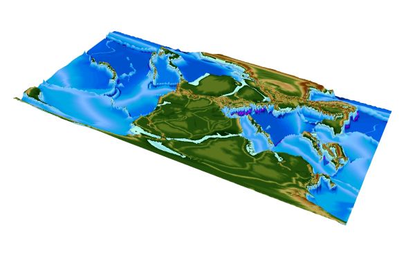
The PANALESIS model is thus the unique academic model in the world that covers 100% of the Earth’s surface (i.e. reconstructing continental and oceanic realms, including the Panthalassic realm) over several Wilson cycles. The model is physically consistent and takes advantage of the wealth of plate tectonics (Vérard et al., 2015.a). Thanks to the conversion into 3D (Vérard et al., 2015.b), full global palæo-DEMs can be generated, and sea-level changes can be assessed by flooding continental areas. Topographies are thus quantified way beyond the sea-shore line, and it has been shown that such characteristic is crucial for carrying out realistic climate modelling in deep time (Perroud et al. 2015; Brunetti et al. 2015; Vérard, 2019.b).
Yet, the PANALESIS model is under development. A preliminary version (or version 0) has been created for the Phanerozoic. Starting at 888 Ma, a new version (version 1) of the model is currently being developed every 10 Ma (i.e. 888 Ma, 880 Ma, 870 Ma, etc.; see Vérard, 2021), and will be soon extended to the Permo-Triassic boundary to fully account for inheritance from one map to another.
Some publications related to the Panalesis model or its developments:
Vérard C. (2019.a). Plate Tectonic Modelling: Review & Perspectives. Geological Magazine, 156 (2), 208-241; doi:10.1017/S0016756817001030.
Vérard C. (2019.b). PANALESIS: Towards global synthetic palæogeographies using integration and coupling of manifold models. Geological Magazine, 156 (2), 320-330; doi:10.1017/S0016756817001042.
Vérard C., Hochard C., Baumgartner P.O. & Stampfli G.M. (2015.a). Geodynamic evolution of the Earth over the Phanerozoic: Plate tectonic activity and palæo-climatic indicators. Journal of Palæogeography, 4 (2), 167-188.
Vérard C., Hochard C., Baumgartner P.O. & Stampfli G.M. (2015.b). 3D palinspastic reconstructions of the Phanerozoic versus sea-level and Sr-ratio variations. Journal of Palæogeography, 4 (1), 64-84.